
The Waterford Heritage Trail (WHT) was incorporated as a charitable organization in 2002. We are a multi-purpose 24 km rail trail combining sections from the former TH&B (Toronto Hamilton and Buffalo RR) and LE&N (Lake Erie and Northern RR) and the Canadian Southern RR, a part of New York Central RR, which ran between Buffalo and Detroit. The Waterford Train Station had eight sets of train tracks and at its height saw 70 trains per day passing through, going north, south, east and west. This great RR heritage is the backbone of the WHT system, which is part of the Trans Canada Trail, allowing all our trail users access to Canada from coast to coast.
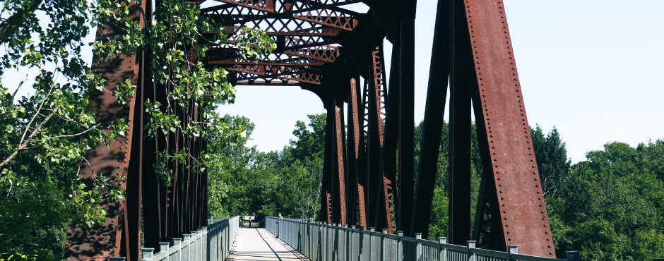
Our “piece de resistance” is the Black Bridge (BB), an elevated RR bridge offering spectacular views of sunrises and sunsets over the various lakes in the area. On any visit you might see kayakers, canoeists, paddleboarders, fishers, skaters, cyclists, hikers, strollers, people using mobility devices and viewers resting on a bench taking in the comings and goings on the BB and Waterford Ponds.
We have paved the trail in and around Waterford and north to the County Line where we merge with the paved Brant Waterways Trail leading to Brantford and on to Hamilton, Cambridge, Paris and beyond.
The WHT includes the Shadow Lake Group who manage the popular trail core focusing on the town of Waterford. To their credit, they have transformed former hazard lands into a well-used community resource.
Rail Trail Network
Norfolk County has 45km of converted rail trails. Starting at the trail access point at Lions Park on Davis Street in Simcoe, it is:
- 9.2 km north to the Waterford Black Bridge on the Waterford Heritage Trail
- 20 km north to Brant County line at Jenkins Road on the Waterford Heritage Trail
Increasing Accessibility
A number of features increase accessibility for trail users.
- The trail is paved from Thompson Rd. to the Brant/Norfolk County Line.
- A staircase now enables access from the main trail down to Shadow Lake Trail around the Waterford Ponds.
- Gate openings: 1 metre minimum to allow room for wheelchairs, bike trailers, etc. to pass through.
- Average grade: 2% maximum
- Cross slope: 2% maximum
- Minimum surface width: 2.5 metres
- Bridges: access slope not exceeding 18%
Trailheads and Access Points [between Brant County and Simcoe]
- Jenkins Road
- Concessions 2 & 3 Townsend
- Norfolk County Road 19 East
- Concessions 5, 6 & 7 Townsend
- Concession 8 Townsend [Mechanic Street]
- Nichol Street
- Thompson Road
- Concessions 10, 11, 12 & 13 Townsend
Parking
Parking for the Waterford Heritage Trail is available at:
- Old Hwy 24 at Bloomsburg
- West end of Nichol Street
- Waterford Ponds Parking Lot on Mechanic Street
- Thompson Road Bridge [coming soon]
Organization: Waterford Heritage Trails & Shadow Lake Park
Membership
Become a member of the fastest growing trail in Norfolk County. Annual fee – $15 individual, $20 family Contact Terry Bonnett
Email: [email protected] Phone: 519-428-0060
Waterford Rail Lands Redevelopment
A committee has been struck to transform the abandoned railway lands that abut the Waterford Ponds, into an attractive functional recreational area. The goal is to enhance the outdoor experience for the residents of Waterford and beyond. Visit our website Waterford Heritage Trails & Shadow Lake Park
From Rail to Trail: The Revival of Shadow Lake

 Beaver Dam


